Pictures from the Phone

Living in modern times is nice, my phone can make pictures! Enjoy a view of Paris as the sun sets.

I've taken to running in the early morning. It allows me to run in the streets without constantly having to stop for old ladies with their shopping carts or having to inhale the exhaust of countless diesels. As such, I've been running without a set destination or path, exploring different neighborhoods. Here is a good example of what I've found (it's Google StreetView, you can drive around and have a look for yourself):
View Larger Map
It's not far from where we live, but I've never seen anything like it in Paris. The stairs to the houses, the gates, the style of the buildings, it all looks like something from Amsterdam or maybe Brooklyn. I'll have to go back to see if there is a plaque somewhere explaining the history of the area.
First, a bit of background. Corsica is part of France as much as Hawaii is part of the US. It just happens to be an island and, as such, has a unique culture. Here's a map:
View Larger Map
Given Corsica's strategic location in the Mediterranean, it's been controlled by many different empires and countries. Over the millennia, it has only had a brief period of sovereignty. (For the full rundown, have a look at Wikipedia's History of Corsica.) That said, the people remain very independently minded which is seen in the island's motto, "Often conquered, never subdued." Unfortunately, this independence of mind has given rise to an armed separatist movement which has, at times, resorted to violence.
That said, we found the island and it's inhabitants extremely warm and welcoming, really it was a fantastic place.
People and Language
Like I said above, everyone that we met was absolutely fantastic. Maybe it's because we're tourists and are contributing to the economy, maybe it's because we were there early in the season, but whatever it was, the people were great.
People spontaneously offered us directions and local history. It was a bit like walking through some educational "period town" where people wearing funny clothes tell you, "Blacksmiths were an important part of the 18th century economy..." Except, in this case, they were wearing normal clothes and told us where we could buy food, where we could find the trail, and the history of the town.
The official language is French (of course) and everyone we met spoke it natively. That said, we also heard a lot of Corsican both spoken and on the radio. The language itself is very close to Italian, with its own variations.
Food
We ate really, really well on the trip. In the gîtes, it was a family-style meal, often with meat, pasta, and/or potatoes. Many of the ingredients were local, from the cheese (brucciu is one local favorite, it's somewhere between feta and ricotta, though it's only available in the spring and early summer) to the meat (goat, mutton, and wild boar being particularly popular).
The island is known for its charcuterie, the best of which comes from the aforementioned wild boar. I ate my fair share, rationalizing that it would really be too bad to miss out on this opportunity. We still have quite a bit in our refrigerator waiting to be eaten...
They drink a lot of wine (red, white, and rosé) which is all locally produced. I don't think that I saw a bottle of wine from the continent on a single restaurant menu. They also have surprisingly good beers, especially Pietra, a brown ale made from chestnuts.
The cuisine of the coasts is different from that of the interior, despite the small size of the island. In the mountains, they eat a lot of meat and cheese (including hard sheep and goat varieties) whereas the cuisine of the coasts includes that as well as plenty of seafood. The Mediterranean influences are clear throughout.
One disappointment was the bread, it was just nothing compared to what you get in Paris.
Hiking on the Trail
The trail itself was usually a narrow path cutting through the forests and scrub land that we crossed. It was marked, usually well, with orange stripes of paint.

We had topographical hiking maps with us, but only ever used them for confirmation of the route and estimating distances.
Life in the gîtes was quite nice. Though it wouldn't satisfy your needs if you were looking for a wilderness experience (I don't think anywhere in Western Europe would...), it is a really civilized way to hike. Your food is prepared for you, you have a bed and a shower every night, really it's quite nice. There is even a service that will transfer your bags from one gîte to the next so that you would, conceivably, never need to carry anything more than your lunch and water while hiking. That seems to defeat the purpose a bit, but it's nice to have the option.
It was also an opportunity to meet other hikers. We met a Swedish couple, a French guy (who had never lived in France) and his German friend, and a bunch of other nice people. There was only one somewhat strange, though even he was quite nice.
The Other Tourists
May is still rather early in the Corsican tourist season which, like most areas in France, peaks in July and August. That said, we were far from the only tourists on the island. It seems to be a popular destination for Germans and Swiss, as well as the French. It is especially popular with motorcyclists. Given the endlessly winding mountain roads, nice climate, and beautiful sights, this isn't much of a surprise. At an ice cream parlor in Porto Vecchio, we shared the terrace with 20 members of a German biker club.
The Roads
Narrow and winding, and all two lanes (or less). There's no highway on the island, and most of the major surface streets follow the coasts. Since we were there early in the season, traffic and parking were never a problem, but I can only imagine how bad it would be at the peak. Entering the popular town of Bonifacio, for example, is done by one, narrow road, in and out. According to the guidebook, it's common to have to wait several hours to be able to enter. Thankfully for us, it wasn't the case.
The Car
Having decided to rent a car for the second half of the trip, I got to drive a Renault for the first time. It was a new model, the Modus:

It had a 1.5L common rail diesel with a mere 85hp but 147ft-lbs of toque. For the driving conditions (narrow, winding mountain roads with plenty of corner exits) it was plenty competent to get around. What's better, it's rated at 52mpg and was averaging 47mpg in the mountains. Not bad at all.
Final Conclusions
In the end, it was one of the best pure vacations ever. Certainly it's nicer to visit family in the US, France, or Israel, but for simply discovering a new place, this trip was really wonderful. The combination of the difficult period at the beginning and the more relaxed period at the end was really ideal.
I hope that it won't be too long before we get back to Corsica...
Following up on the previous post about hiking the Mare a Mare Sud, here's the chronology of events for the rest of the trip.
Thursday, May 7
We woke up slowly in the tent, did laundry, and made our way to Porto Vecchio. We saw the sea (thereby officially ending the hike) while we had lunch in the port.

The town is full of interesting old buildings, walls, and gates.


We decided it would be best to rent a car to be able to explore more of the island, as well as to have a place to lock up our stuff (since we were staying in campsites). The first thing we did with the car was to drive to an out of the way beach and lay out in the sun for a while.

The view out to sea was quite impressive:

While on the beach, we chose a restaurant from the guide book and drove out there. It's called Le Passe Temps (The Pass Time, obviously) and was really delicious. Esther had grilled pork and I had a pizza from their wood-fired oven. We were quite lucky because they had only opened for the season that night. It was clearly popular with the locals, the owners were a bit distracted as their friends kept pulling them aside to talk to them.
Friday, May 8
We drove around quite a bit, passing many of the towns that we crossed while hiking and seeing others that we couldn't quite get to. I've traced our route on the map below. Leaving from Porto Vecchio, we saw L'Ospedale, Zonza, Levie, Santa Lucia, Sartène, and finally Bonifacio.
View Drive 1 in a larger map
As one can imagine, there were plenty of wonderful sights. A sampling:


Sartène was particularly impressive with its narrow, convoluted streets and passageways.


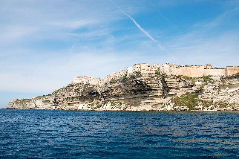
We arrived in Bonifacio, our final destination, in the late evening. It is another impressive city as it's built onto the white cliffs that overlook the southern tip of the island.

The geology forms a nearly perfect natural harbor, in which a marina has been built which has become popular with mega-yachts. (Fun fact! The natural harbor of Bonifacio is believed to have been visited by Odysseus during his travels in The Odyssey, given how closely it matches the description.)


The city, like Sartène, also has beautiful, narrow streets, full of intriguing details.


Night fell, we had dinner on the port, and made our way back to the campsite, exhausted once again.

Saturday, May 9
On our last full day in Corsica, we started by walking out to the lighthouse outside of Bonifacio. The view was incredible.

Coming back in, we took a boat tour of the cliffs and the lagoons around Bonifacio.


We continued our explorations, making our way up to the archaeological site of Filitosa. The site has been inhabited for about 7,000 years by various tribes, one of which built many (rather phallic) statues which apparently depicted their enemies. It was impressive to be on such an old site.

Everything was old there, even the big olive tree in the center of these statues is thought to be 1,200 to 2,000 years old.

Finally, for our last dinner in Corsica, we decided to explore the small town of Campomoro. It required driving out on a harrowing road. You may have images of "dangerous road" in your mind; this must be the model. It was a strip of pavement about one and a third lanes wide, with no lane markings, no guardrails, and no shoulders stuck to the side of the cliff. Oncoming traffic (which there was thankfully very little) meant coming to a near stop and narrowly brushing by. To make matters worse, there were often cattle and sheep on the side or in the middle of the road. In short, quite an adventure.
View Untitled in a larger map
The effort however, was well worth the beach and the dinner. The beach was just about perfect and the dinner (at the nice hotel in town) was fantastic. Bonifacio-style eggplants (aubergines à la bonifacienne) may be the best food I've ever tasted.


We said goodbye to the sea and the mountains, and made our way back to the campsite. (Back along the same road, now in the dark.)
Sunday, May 10
We were supposed to get up and leave, but little did we know, Corsica had one last surprise for us.
We had some extra time so we decided to have a coffee up in the old city of Bonifacio. We went to the first, cheapest-looking place that we saw, ordered our coffee and croissants (it's still France, after all), made our way to the back of the cafe and were greeted with the following sight:

We had our coffee and croissants (technically, Esther had a pain au chocolat) overlooking both the sea and the cliffs. A wonderful surprise, and a wonderful end to a fantastic trip.
Rather than posting one massive "Our Trip to Corsica" post, I think it might be a bit easier to split things up. First, you'll have a "Just the facts, ma'am" chronology of the hike which will then be followed by a chronology of our other travels. I'll finish off with our more subjective impressions. This (of course, given the title) is the chronology of the hike.
There are, of course, plenty of photos in the album, nearly all with captions that add some details to the story.
 |
| Travels - Corsica 2009 |


Esther and I will be spending the next week in Corsica. A few weeks ago we took the suburban train out to a forest to get some mud on your boots. I couldn't help but make stupid faces for the camera.
I'll bring back plenty of pictures from Corsica, expect updates the week of May 11th.

One more reason to like Paris: These guys walking through the streets, playing their music. I tossed them a euro from the window.

